
|
Public Helpline

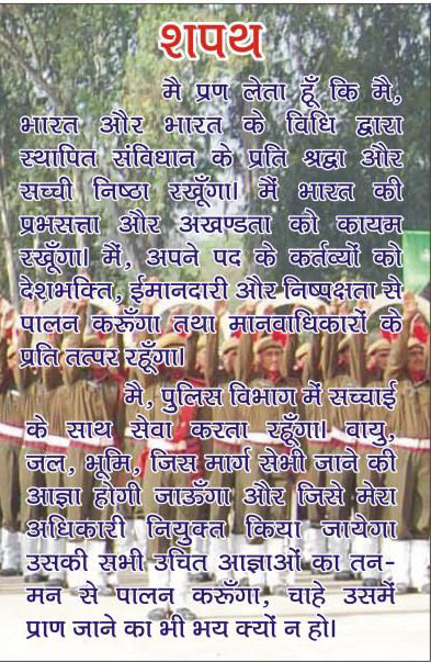
Police Oath
Sirsa at a Glance
In 1837A.D. the site of the town of Sirsa, Once a populous and flourishing mart, was wholly deserted. There was no village, not even a single inhabited hut, though the brick walls of shores of houses, uninhabited since the famine of 1783, were still standing. But the traditions of its former prosperity were not forgotten, and numerous merchants residing in the neighboring Rajputana States repeatedly urged captain Thorsby to restore the town. Soon after resuming charge of the district he took up the scheme and applied for sanction, and the Lieutenant-Governor in according his hearty approval remarked that the recovery of the Bhatt territory from a state of waste and its conversion in to a populous country was the Principal object contemplated in the nomination of a separate Superintendent for that tract, and that the restoration of the old town of Sirsa was likely to greatly further this object. In January 1838 Captain Thorsby called together the merchants and others who wished to settle in the new town, and made a commencement in the uninhabited jungle to the east of where the old town of Sirsa was. This site was chosen because of the good quality of the water, the number of old masonry wells in the neighborhood the proximity of the old fort with its in exhaustible supply of good brunt bricks, and the associations and traditions connected with the old town of Sirsa. The high Jungle which than covered the site was cleared away, the lines of the walls and streets were marked out by bamboos and flags, and the work was at once commenced by large gangs of convicts and numerous free laborers. The town was laid out as a square, crossed by broad streets at right angles to each other, and thus presents an appearance of regularity very seldom seen in an Indian town. A ditch and rampart were made round it in order to afford the protection which the merchants thought necessary in the state of the country; building sites were allotted to the numerous applicant, and notwithstanding such difficulties as were caused by the drought of 1838 and the visitation of cholera, within a year many hundreds of building had been finished and the foundation of about two thousand altogether had been laid, the total cost to Government being only about Rs. 6,000. The town continued to grow in size and importance as the surrounding country become more fully colonized. It was soon made the head-quarters of the Bhatti Territory, and become the great emporium for the trade of the neighborhood, and by collection large stores of grain made the country much safer against sudden scarcities.
Owing to the arid nature of the country and the want of irrigation there are few trees round the town or in its immediate neighbourhood. In addition to the native town there is a railway settlement on the north side of the line, containing the residence of the railway officials and subordinates.
There are numerous antiquities in and around Sirsa, relics of its ancient, predecessor, the town of Sarsuti. The most remarkable is the old fort, a large irregular mound to the north-west of the town, and now full of ancient bricks, the debris of original fort. It is one of the oldest places in India. There are also numerous Hindu temples and Musalman mosques and tombs around the town.
The principal public institutions are the school and dispensary and the Municipal Hall. The other public buildings are the sub-Divisional Officer’s katchery which forined the old District katchery; near it is the tahsil: both are north-east of the town on either side of the Railway. There is also a thana, a staging bungalow and a Police rest-house. Inside the town is a qurdwara supported by the Sikhs, and a large masonry building called the katra, and intended for a market. A large and handsome mosque has been recently built by the musalmans of the neighbourhood.
Rania is an old Bhatti village in the valley of Ghaggar. It was formerly the seat of the Bhatti Nawab and remained inhabited all though the time of the anarchy which preceded British rule. It has not much trade and is simply a large village. The majority of the inhabitants are musalmans, chiefly Rains, Joiyas, and Bhattis engaged in the cultivation of the rice and wheat lands of Raina and the neighbouring villages. Sirsa district came into existence w.e.f. 1.9.1975. Previously it was a sub division of District Hisar.
Total area of this district is 4279.40 Sq Kilo Meters. It has 288 KMs long border out which 150 KMs adjoin with Punjab and 100 KMs with Rajasthan. The geographical situation of this district is very sensitive. The law and order situation in the district is well under control. National Highway No. 10 passes through the jurisdiction of this district. Besides three Railway lines i.e. Rewari to Fazilka, Bhatinda to Hanumangarh and Sadalpur to Hanumangarh passes through the district
This district is dividesd into four sub-divisions i.e. Sirsa, Dabwali, Ellenabad and Kalanwali. There are 16 Police Stations functioning in this district. This district has 323 villages. Population Census of Sirsa District in 2011 is 12,95,189. Literacy rate of Sirsa is 68.82 percent. Sex Ratio for Sirsa district is 897 per 1000 male. The area of Police Stations Baragudha, City Sirsa, Sadar Sirsa, Rania and Ellenabad of this district is flood affected.